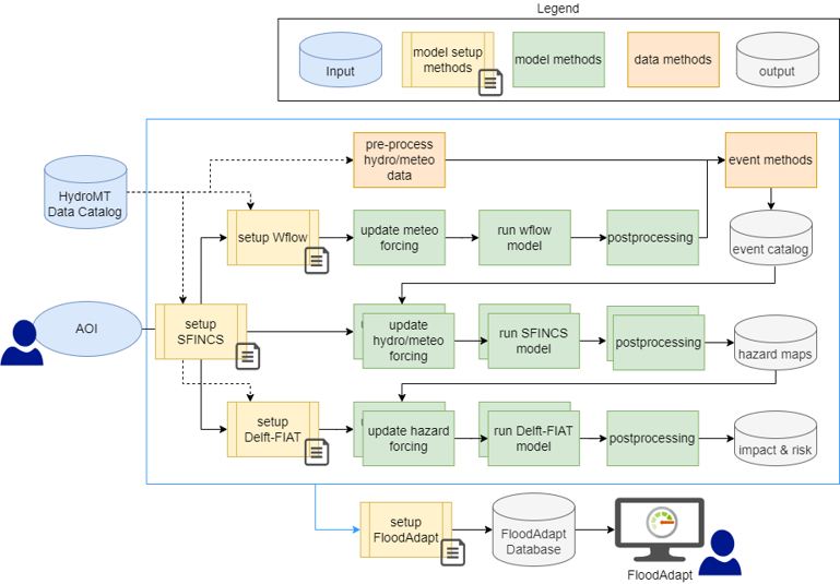
HydroFlows is a modular toolset for conducting rapid flood risk assessments and designing climate adaptation solutions, particularly in urban areas vulnerable to rainfall extremes and riverine flooding. It enables cities to assess flood hazards quickly and effectively, helping identify where nature-based solutions (NBS) and resilient infrastructure can have the greatest impact. HydroFlows consists of two core components: a library of building blocks for flood risk analysis workflows and a framework to assemble and run workflows across multiple engines using both global and local data. Its mission is to automate and standardize flood risk assessment processes - starting with global data - and empower local professionals to conduct their own scenario modeling and adaptive planning. By making workflows repeatable and flexible, HydroFlows lowers barriers to expert-level assessment and helps mainstream flood resilience into urban planning practices.
The city of Rio de Janeiro’s Sustainable Development and Climate Action Plan (PDS) prioritizes adaptation to climate extremes, and HydroFlows contributes to this goal through the Acari River Basin case study. The tool helps identify flood-prone areas affecting people, infrastructure, and ecosystems; supports the integration of green-blue infrastructure into the city’s masterplan; and provides detailed flood hazard and impact maps for the Acari River Basin. It also assists in evaluating the usefulness of global datasets while highlighting the added value of incorporating local data for improved accuracy. RioÁguas, the municipal flood risk authority, is applying HydroFlows in collaboration with Deltares to develop and refine a new urban drainage masterplan.
Dr. Hans Gehrels
Hans.Gehrels@deltares.nl

Dr. Dirk Eilander
Dirk.Eilander@deltares.nl

Eilander, Dirk, Hélène Boisgontier, Laurène J. E. Bouaziz, Joost Buitink, Anaïs Couasnon, Brendan Dalmijn, Mark Hegnauer, (2023). HydroMT: Automated and Reproducible Model Building and Analysis. Journal of Open Source Software 8, no. 83 (March 7, 2023): 4897. https://doi.org/10.21105/joss.04897.
Eilander, D., Gehrels, H., Tromp, W., Tsiokanos, A., Rautenbach, S., Roscoe, K., Fraga, J. P., and Ney de Montezuma, P. (2025). Rapid and continuous flood risk assessment and adaptation planning for climate resilient developments: a Rio de Janeiro case study. Conference presentation. 12th International Conference on Urban Climate, Rotterdam.
Gehrels, H., Eilander, D., Tromp, W., Tsiokanos, A., Rautenbach, S., Roscoe, K., Fraga, J. P., and Ney de Montezuma, P. (2025). Rapid flood risk assessment and adaptation planning for climate resilient developments: a Rio de Janeiro case study, EGU General Assembly 2025, Vienna, Austria, 27 Apr–2 May 2025, EGU25-18351, https://doi.org/10.5194/egusphere-egu25-18351.
Leijnse, T. W. B. (2025). Riding the wave: Enabling large-scale wave-resolving probabilistic coastal compound flood modeling. [PhD-Thesis - Research and graduation internal, Vrije Universiteit Amsterdam]. https://doi.org/10.5463/thesis.1031
Leijnse, T., Maarten van Ormondt, Kees Nederhoff, Ap van Dongeren. (2021). Modeling compound flooding in coastal systems using a computationally efficient reduced-physics solver: Including fluvial, pluvial, tidal, wind- and wave-driven processes, Coastal Engineering, Volume 163, 103796, ISSN 0378-3839, https://doi.org/10.1016/j.coastaleng.2020.103796. (https://www.sciencedirect.com/science/article/pii/S0378383920304828)
Tromp, W., Eilander, D., Winsemius, H., De Jong, T., Dalmijn, B., Gehrels, H., and Backeberg, B. (2025). Flexible and scalable workflow framework HydroFlows for compound flood risk assessment and adaptation modelling, EGU General Assembly 2025, Vienna, Austria, 27 Apr–2 May 2025, EGU25-8114, https://doi.org/10.5194/egusphere-egu25-8114.
Websites and Software downloads:
FloodAdapt:
https://www.deltares.nl/en/software-and-data/products/floodadapt
https://deltares-research.github.io/FloodAdapt/
FloodAdapt Fact Sheet | Homeland Security
HydroFlows:
https://deltares-research.github.io/HydroFlows/
Rapid and continuous flood risk assessment and adaptation planning for Rio de Janeiro -
SFINCS:
https://www.deltares.nl/en/software-and-data/products/sfincs


